Project update
Council considered the comments raised in submissions at its 15 September 2025 meeting.
The final Code Amendment documentation, together with an Engagement Report, which includes all submissions received during consultation as well as feedback on how well our engagement process was, will be submitted to the Minister for Planning for a final decision. If the Minister for Planning resolves to approve the Code Amendment, it will be consolidated into the online Planning and Design Code and reflected in the online mapping tool. The Minister for Planning may also resolve to refuse the proposed Code Amendment or seek alterations to the Code Amendment.
There is no set timeline for the process outlined above, but it is anticipated that the process would be concluded by late 2025/early 2026. Once a decision has been made, Council will write to advise you of the outcome of the Code Amendment and where you can access a copy of the Engagement Report.
Document Library
About the project
The ‘zone’ set by the State Government’s Planning and Design Code does not reflect the community, tourism, cultural, educational and visitor-related land uses of the Goolwa Wharf precinct.
Council sought community feedback on a ‘Code Amendment’ to create a ‘Goolwa Wharf Subzone’ within the current zone.
It is a unique area, with historical significance and attracts a strong visitation of locals and tourists.
About the Current Zone (outdated)
- The current zone consists of policies with a focus on accommodating marina and passenger ferry services, and associated infrastructure.
- The Infrastructure (Ferry and Marina Facilities) Zone, however, does not seek to foster the community, tourism, cultural, educational and visitor-related aspirations of the Goolwa Wharf precinct.
Proposed New Policy – ‘Goolwa Wharf Subzone’
- The proposed new Goolwa Wharf Subzone will foster the community, tourist, cultural and recreational aspirations of the Goolwa Wharf precinct, reinforced by the area's First Nations and historic significance.
Why are we doing this?
- The new Goolwa Wharf Subzone policy will enable future alterations (subject to development approval) to enhance current and envisaged land uses and infrastructure.
- As part of the Code Amendment process, engagement with the community and key stakeholders is required.
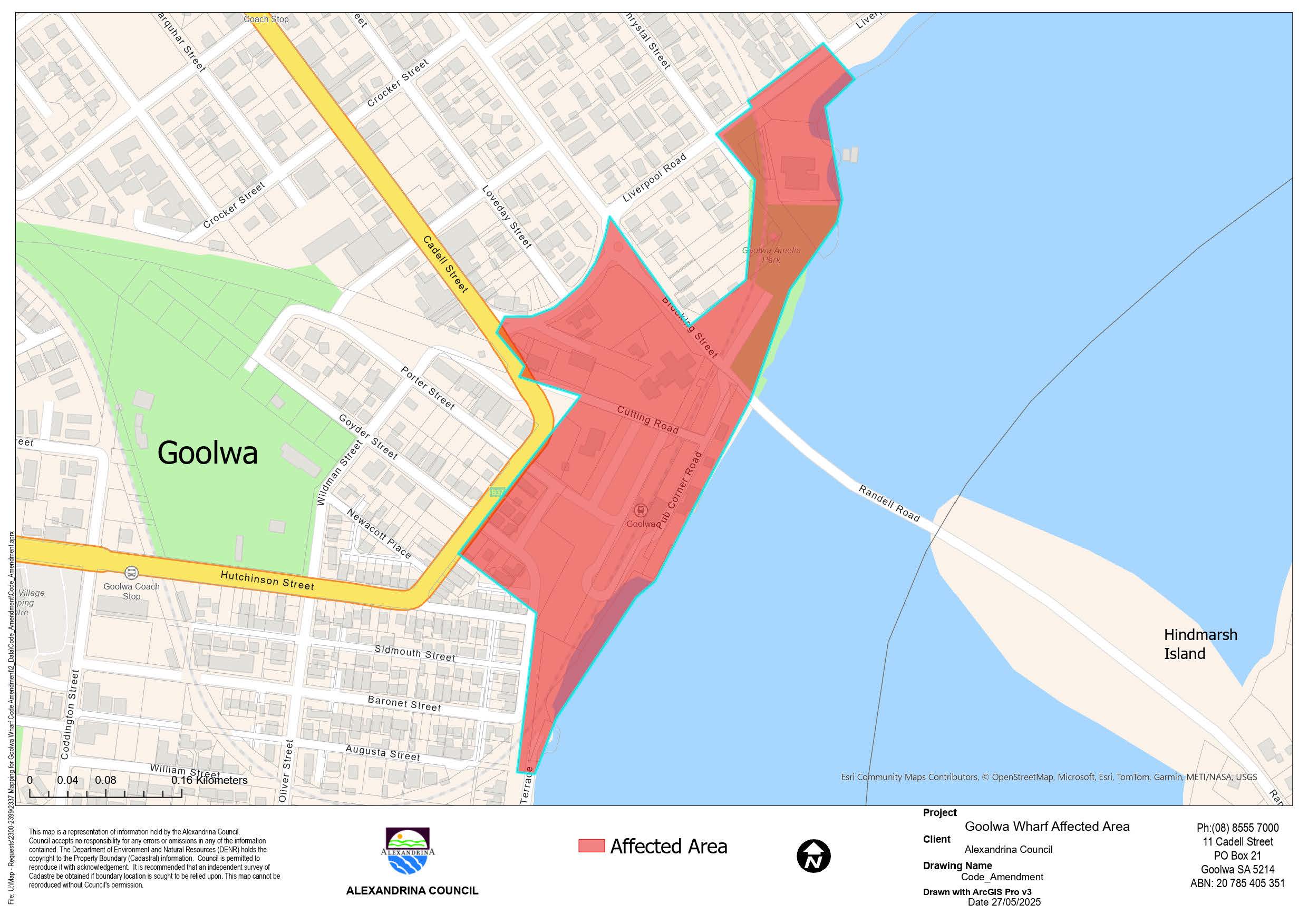
Who will be affected? See the map of the Affected Area that will be subject to the proposed new Goolwa Wharf Subzone. | Who does this not affect?
|
Key documents for consultation
Summary of engagement
We received a total of 25 submissions; five (5) opposing the draft Code Amendment and 20 in favour of the Code Amendment.
Concerns raised in relation to the Code Amendment include:
- There are existing houses and some businesses in the current Zone which should not be subject to the current Zone
- No support for additional diversity of land uses, and commercial land uses should be limited
- Concerned that the wharf area will be developed into a large-scale café style precinct and/or with apartment-style development
- Policy should retain the green spaces and charm of the Goolwa Wharf
- Policy should retain the heritage character and buildings of the Goolwa Wharf precinct; has historically been a commercial wharf and an area of manufacturing and production related to the towns’ paddle steamer heritage
- Concerns that there was insufficient promotion of consultation (social media posts, mail out to all residents)
- No support for marina type facility
- Restrict hazards and flammable goods in the region
- Parking is not adequately addressed
- To prevent inappropriate development, Goolwa Wharf precinct requires development guidelines and an activation plan, with supporting governance structure.
- Exclude ‘tourist accommodation’ from the envisaged land uses
- ‘Arts and Culture’ is not recognised by proposed policy
- Any unauthorised signage should be removed.
Submissions in support of the draft Code Amendment provided the following comments and suggestions:
- Will revitalise the precinct as there is no activity outside of the school and public holidays
- Support for policy that respects the heritage and First Nations cultural heritage which makes Goolwa Wharf a signature destination for locals and visitors
- Support for policy that seeks adaptive reuse of heritage buildings
- Support for the retention of the River Murray Flood Plain Protection Overlay
- Community facilities (such as BBQ area) between Amelia Park playground and boat building shed should be considered
- Use for the Old Harbour Master House to be considered
- Improvements to the footpath for prams, from the train station ticket office to Hays Street (along Dunbar Street)
Key terms
Planning and Design Code
In 2021, the new planning system established under the Act became operational for all Councils across the State. All existing Development Plans were revoked and replaced with the Planning and Design Code (the Code).
The Code outlines how you can and cannot develop your property. It is publicly accessible on PlanSA.
Any proposed changes to the Code requires a ‘Code Amendment’, which is underpinned by a thorough engagement process.
The Act
The Planning, Development and Infrastructure Act 2016 is the relevant planning legislation that establishes the planning and development system and provides for infrastructure planning.
Zone
Every part of the State is zoned to guide the types of development that are and aren’t appropriate.
Development Act 1993
Was the former relevant planning legislation that has been fully repealed and replaced by the Planning, Development and Infrastructure Act 2016.
Infrastructure (Ferry and Marine Facilities) Zone
The existing zone, Infrastructure (Ferry and Marina) Facilities Zone supports marina, passenger ferry services and port activities and compatible land uses.


